Duplicate from http://www.exactaweather.com/UK_Long_Range_Forecast.html
Summer 2011 – Recap to date
June 2011
June turned out to be very wet and unsettled across the UK. Rainfall was largely above average, with many areas seeing more than 150% of their normal rainfall amounts, including drought hit eastern areas.
June was also the coldest in the UK for 10 years, with Northern Ireland experiencing their coolest June in 25 years. The mean Central England Temperature (CET) data for June was -0.4C below average.
July 2011
July also turned out to be relatively wet and unsettled across many parts of the UK. Certain parts of England and Scotland received 200% of their normal rainfall amounts, with rainfall amounts elsewhere more near average overall.
July was also the coldest in the UK for over 10 years, with minimum temperature resulting in the coldest July across the UK in over 30 years. The minimum Central England Temperature (CET) data had a significant anomaly of -1.1C. Although it has felt more pleasant at times with less rainless days during July in certain regions, the mean Central England Temperature (CET) data for July was -0.8C below average. Other long range forecasters failed to consider the intensity of the rainfall when it occurred or the minimum temperature, just as they will underestimate the intensity of snowfall and below average temperatures this winter.
Grey Skies
Many regions across the UK have also experienced notable grey skies due to above average cloud cover, as I originally forecast. I expect this trend to continue as I have outlined many times, due to the low levels of solar activity that we have experienced in recent years.
Original Forecast
I originally issued my UK summer forecast on the 30th January this year, well in advance of any other forecaster worldwide.
It read “Summer 2011”
“It would be adequate to suggest below average temperatures in terms of how I calculate solar activity in my forecasts, so it looks like a summer of grey skies and damp weather, and it's probably safe to say that there will be no BBQ summer again this year”.
I also issued a warning for torrential downpours and severe flooding.
Summer 2011 Publications
I provided the Sunday Sun and Chronicle with my 2011 UK summer forecast in early April which read
“But, sun worshippers have been warned to make the most of the hot weather as long range forecasters say the outlook for summer is gloomy. James Madden said judging by solar activity and the current ocean atmosphere, the UK could see more rain and a dip in temperatures in June, July, and August. He said: “based on the factors covered, the summer as a whole could unfortunately be colder than average with above average rainfall. “In my opinion, odds of a barbecue summer this year are slim.”
http://www.sundaysun.co.uk/news/north-east-news/2011/04/10/north-east-makes-the-most-of-the-lovely-weather-79310-28487833/
http://www.chroniclelive.co.uk/north-east-news/evening-chronicle-news/2011/04/09/tyneside-is-in-for-a-scorcher-of-a-weekend-72703-28487268/
August will have to show a major improvement to avoid a cold and wet UK summer this year. As it stands at present with more unsettled weather in store, a colder than average summer with above average rainfall is looking extremely likely as I originally forecast. The torrential downpours and severe flooding that we have seen in early August, have already seen parts of Yorkshire receive more than one month's rainfall in just 12 hours. Parts of north-east England and Northern Ireland also experienced severe conditions due to localised flooding, with further flood alerts also put in place across Northern England and Scotland.
http://uk.news.yahoo.com/northern-england-put-flood-alert-104014593.html
http://www.guardian.co.uk/uk/2011/aug/04/flash-floods-yorkshire-torrential-rain
http://www.mirror.co.uk/news/top-stories/2011/08/08/woman-dies-as-floods-batter-scotland-and-the-north-115875-23327860/
La Niña Watch – Update
The Climate Prediction Center recently issued a ENSO alert system status for a (La Niña Watch).
I clearly stated in March and May of this year that
“NOAA predictions give a 50% chance that La Niña conditions will be all but gone by June 2011. I personally feel that this prediction is wrong and once again way underestimated, hence my future flood warnings.”
“Recent NOAA predictions give a 50% chance that La Niña will have completely disappeared by June 2011. However, I am not convinced that it will completely disappear. Recent indicators may suggest neutral conditions for the season ahead, but it is also important to take forecast accuracy into consideration for this time of year and the current phase of PDO. The possibility of La Niña redeveloping will become clearer over the next few months.”
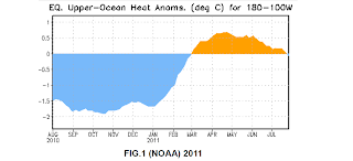
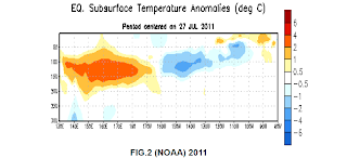
Strictly this is true, as atmospheric circulation anomalies still reflect aspects of La Niña. The subsurface oceanic heat content in the upper parts of the equatorial pacific continued to weaken (FIG.1) with strengthening subsurface anomalies in the east-central pacific (FIG.2), hence the La Niña watch that has been issued.
As expected, it is still clearly visible to see from present day NOAA satellite images that no improvements have been offered in regards to the Gulf Stream and North Atlantic drift.
The surface horizontal current (0m in depth) should be more comparable to the image in (FIG.3 – August 2009) below than (FIG.4 – August 2011), in order for the UK and Western Europe to benefit from this valuable heat source.
I clearly stated in early August 2010 that “the strength of the current seemed to be in a position that would no longer feed towards the UK or Northern Europe, due to a breakage that appeared in the gulf loop current”. I have also clearly stated in many of my posts that “if nothing improved soon in regards to the Gulf Stream and North Atlantic drift, that this would begin to alter the climate of the UK, especially more so in winter”.
Even at depths of (100m) nothing improves in (FIG.5) below. This is especially important if we compare this to the surface horizontal current of (0m) in 2009 in (FIG.3) below.


Solar Activity
One of the main factors I have strongly emphasised on within my forecasts, is my thesis on future levels of low solar activity.
31st January 2011
Geomagnetic activity is minimal, this will result in extra cloud cover and alter temperatures, with further repercussions of prolonged periods of low solar activity in the future, that could see sunspots vanish.
15th November 2010
The will also have future effects on further periods of prolonged low solar activity.
19th September 2010
This has future effects on further periods of low solar activity, which means more spotless days and more prolonged periods of low solar activity.
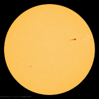
Recent scientific research from the National Solar Observatory (NSO), strongly indicate that the next 11 year solar cycle, will be greatly reduced or may not happen at all. Although some sunspots are visible at present (FIG.6), solar activity is minuscule in comparison to what it should be and according to all NASA's predictions to date. I stated in April 2009 that
“David Hathaway is a well respected solar physicist for NASA, who recently reported that there was nothing wrong with the sun on the highly respected NASA website. He stated that the average length of a solar cycle is 131 months with a standard deviation of 14 months. In October 2008 this was 145 months and the standard deviation of 14 months was officially over, which means we are now 6 months (April 2009) outside of his prediction. Although Hathaway suggests that the current solar cycle does not worry him, anticipating many more spotless days before a return to solar max conditions in around 2012? His theories appear very confusing for a scientist who has claimed to of cracked the suns conveyor belt as far back as 1890.”
Since then NASA and Hathaway have admitted that they were wrong about their predictions in a new scientist article in June 2010. Hathaway also recently stated that we will not reach the 150-200 sunspots as they predicted in 2006, we will instead be heading for a drastic decline that will place us in the lowest sunspot cycle in centuries. As I have stated before this will have future repercussions on further periods of prolonged low solar activity.
The low solar activity that we have experienced in recent years, will once again influence the pattern of the jet stream this winter due to the cooling of the stratosphere. This will block warm air from reaching the UK and create more moisture in terms of snowfall. When high pressure builds towards Greenland (Greenland High) this allows extremely cold easterlies or north-easterlies to develop.
Combined with the other factors that I have covered, this will result in an early start to winter with prolonged periods of cold and widespread heavy snowfall that will see many parts of Scotland/Scottish Highlands, Northern Ireland, North-east England, and Northern England get particularly hard hit throughout. I still expect to see records broken with widespread disruption from snowfall that will once again be hugely underestimated by others.
I posted this satellite image back in January 2010 below (FIG.7) and stated that “this is most probably a taste of our near future in the UK.”

Then this happened in December 2010, only 11 months later (FIG.8)
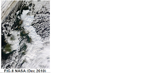
I will not be surprised when I can post another satellite image similar to these for the 2011-2012 UK winter.

Our Winter 2011-2012 Publications
Here we have links to what must be the earliest ever publications in regards to an upcoming UK winter below. Maybe this tells us all something?
http://www.strathspey-herald.co.uk/News/No-sun-and-a-severe-weather-warning-21062011.htm
http://www.derryjournal.com/news/local/expert_warns_arctic_winters_on_the_way_1_2826532
http://www.irishweatheronline.com/news/climate-news/severe-weather-warning-issued-for-winter-2011-12/20748.html
http://www.guardian.co.uk/uk/the-northerner/2011/jun/22/winter-forecast-sharrow-bay-miller-howe-tesco-stockton-on-tees-campaign-for-wool
http://www.naturalnews.com/033178_radical_weather_extremes.html
http://www.reuters.com/article/2011/06/13/idUS77740+13-Jun-2011+BW20110613
And finally here is some food for thought to leave you all with. The Met Office is to be investigated by MPs following the outcry over the barbecue summer and continuing questions over climate change. The Met office has also come under extreme scrutiny after handing out up to £1.5 million in bonuses, yet they don't issue long range forecasts?
http://www.telegraph.co.uk/earth/earthnews/8648215/MPs-inquiry-into-Met-Office.html
Please feel free to check any of the statements that I have made previously within my past forecasts/blog.
James Madden (UK Long Range Forecaster)
http://www.exactaweather.com/
Published: 7th August 2011 (09:12) BST
Content copyright © 2010-2011. Exacta Weather. All rights reserved.
Summer 2011 – Recap to date
June 2011
June turned out to be very wet and unsettled across the UK. Rainfall was largely above average, with many areas seeing more than 150% of their normal rainfall amounts, including drought hit eastern areas.
June was also the coldest in the UK for 10 years, with Northern Ireland experiencing their coolest June in 25 years. The mean Central England Temperature (CET) data for June was -0.4C below average.
July 2011
July also turned out to be relatively wet and unsettled across many parts of the UK. Certain parts of England and Scotland received 200% of their normal rainfall amounts, with rainfall amounts elsewhere more near average overall.
July was also the coldest in the UK for over 10 years, with minimum temperature resulting in the coldest July across the UK in over 30 years. The minimum Central England Temperature (CET) data had a significant anomaly of -1.1C. Although it has felt more pleasant at times with less rainless days during July in certain regions, the mean Central England Temperature (CET) data for July was -0.8C below average. Other long range forecasters failed to consider the intensity of the rainfall when it occurred or the minimum temperature, just as they will underestimate the intensity of snowfall and below average temperatures this winter.
Grey Skies
Many regions across the UK have also experienced notable grey skies due to above average cloud cover, as I originally forecast. I expect this trend to continue as I have outlined many times, due to the low levels of solar activity that we have experienced in recent years.
Original Forecast
I originally issued my UK summer forecast on the 30th January this year, well in advance of any other forecaster worldwide.
It read “Summer 2011”
“It would be adequate to suggest below average temperatures in terms of how I calculate solar activity in my forecasts, so it looks like a summer of grey skies and damp weather, and it's probably safe to say that there will be no BBQ summer again this year”.
I also issued a warning for torrential downpours and severe flooding.
Summer 2011 Publications
I provided the Sunday Sun and Chronicle with my 2011 UK summer forecast in early April which read
“But, sun worshippers have been warned to make the most of the hot weather as long range forecasters say the outlook for summer is gloomy. James Madden said judging by solar activity and the current ocean atmosphere, the UK could see more rain and a dip in temperatures in June, July, and August. He said: “based on the factors covered, the summer as a whole could unfortunately be colder than average with above average rainfall. “In my opinion, odds of a barbecue summer this year are slim.”
http://www.sundaysun.co.uk/news/north-east-news/2011/04/10/north-east-makes-the-most-of-the-lovely-weather-79310-28487833/
http://www.chroniclelive.co.uk/north-east-news/evening-chronicle-news/2011/04/09/tyneside-is-in-for-a-scorcher-of-a-weekend-72703-28487268/
August will have to show a major improvement to avoid a cold and wet UK summer this year. As it stands at present with more unsettled weather in store, a colder than average summer with above average rainfall is looking extremely likely as I originally forecast. The torrential downpours and severe flooding that we have seen in early August, have already seen parts of Yorkshire receive more than one month's rainfall in just 12 hours. Parts of north-east England and Northern Ireland also experienced severe conditions due to localised flooding, with further flood alerts also put in place across Northern England and Scotland.
http://uk.news.yahoo.com/northern-england-put-flood-alert-104014593.html
http://www.guardian.co.uk/uk/2011/aug/04/flash-floods-yorkshire-torrential-rain
http://www.mirror.co.uk/news/top-stories/2011/08/08/woman-dies-as-floods-batter-scotland-and-the-north-115875-23327860/
La Niña Watch – Update
The Climate Prediction Center recently issued a ENSO alert system status for a (La Niña Watch).
I clearly stated in March and May of this year that
“NOAA predictions give a 50% chance that La Niña conditions will be all but gone by June 2011. I personally feel that this prediction is wrong and once again way underestimated, hence my future flood warnings.”
“Recent NOAA predictions give a 50% chance that La Niña will have completely disappeared by June 2011. However, I am not convinced that it will completely disappear. Recent indicators may suggest neutral conditions for the season ahead, but it is also important to take forecast accuracy into consideration for this time of year and the current phase of PDO. The possibility of La Niña redeveloping will become clearer over the next few months.”
Strictly this is true, as atmospheric circulation anomalies still reflect aspects of La Niña. The subsurface oceanic heat content in the upper parts of the equatorial pacific continued to weaken (FIG.1) with strengthening subsurface anomalies in the east-central pacific (FIG.2), hence the La Niña watch that has been issued.


Gulf Stream/North Atlantic Drift
As expected, it is still clearly visible to see from present day NOAA satellite images that no improvements have been offered in regards to the Gulf Stream and North Atlantic drift.
The surface horizontal current (0m in depth) should be more comparable to the image in (FIG.3 – August 2009) below than (FIG.4 – August 2011), in order for the UK and Western Europe to benefit from this valuable heat source.
I clearly stated in early August 2010 that “the strength of the current seemed to be in a position that would no longer feed towards the UK or Northern Europe, due to a breakage that appeared in the gulf loop current”. I have also clearly stated in many of my posts that “if nothing improved soon in regards to the Gulf Stream and North Atlantic drift, that this would begin to alter the climate of the UK, especially more so in winter”.
Even at depths of (100m) nothing improves in (FIG.5) below. This is especially important if we compare this to the surface horizontal current of (0m) in 2009 in (FIG.3) below.


Solar Activity
One of the main factors I have strongly emphasised on within my forecasts, is my thesis on future levels of low solar activity.
31st January 2011
Geomagnetic activity is minimal, this will result in extra cloud cover and alter temperatures, with further repercussions of prolonged periods of low solar activity in the future, that could see sunspots vanish.
15th November 2010
The will also have future effects on further periods of prolonged low solar activity.
19th September 2010
This has future effects on further periods of low solar activity, which means more spotless days and more prolonged periods of low solar activity.
Recent scientific research from the National Solar Observatory (NSO), strongly indicate that the next 11 year solar cycle, will be greatly reduced or may not happen at all. Although some sunspots are visible at present (FIG.6), solar activity is minuscule in comparison to what it should be and according to all NASA's predictions to date. I stated in April 2009 that
“David Hathaway is a well respected solar physicist for NASA, who recently reported that there was nothing wrong with the sun on the highly respected NASA website. He stated that the average length of a solar cycle is 131 months with a standard deviation of 14 months. In October 2008 this was 145 months and the standard deviation of 14 months was officially over, which means we are now 6 months (April 2009) outside of his prediction. Although Hathaway suggests that the current solar cycle does not worry him, anticipating many more spotless days before a return to solar max conditions in around 2012? His theories appear very confusing for a scientist who has claimed to of cracked the suns conveyor belt as far back as 1890.”
Since then NASA and Hathaway have admitted that they were wrong about their predictions in a new scientist article in June 2010. Hathaway also recently stated that we will not reach the 150-200 sunspots as they predicted in 2006, we will instead be heading for a drastic decline that will place us in the lowest sunspot cycle in centuries. As I have stated before this will have future repercussions on further periods of prolonged low solar activity.
The low solar activity that we have experienced in recent years, will once again influence the pattern of the jet stream this winter due to the cooling of the stratosphere. This will block warm air from reaching the UK and create more moisture in terms of snowfall. When high pressure builds towards Greenland (Greenland High) this allows extremely cold easterlies or north-easterlies to develop.
Combined with the other factors that I have covered, this will result in an early start to winter with prolonged periods of cold and widespread heavy snowfall that will see many parts of Scotland/Scottish Highlands, Northern Ireland, North-east England, and Northern England get particularly hard hit throughout. I still expect to see records broken with widespread disruption from snowfall that will once again be hugely underestimated by others.

FIG.6 NASA (7th Aug 2011)
I posted this satellite image back in January 2010 below (FIG.7) and stated that “this is most probably a taste of our near future in the UK.”

Then this happened in December 2010, only 11 months later (FIG.8)

I will not be surprised when I can post another satellite image similar to these for the 2011-2012 UK winter.

Here we have links to what must be the earliest ever publications in regards to an upcoming UK winter below. Maybe this tells us all something?
http://www.strathspey-herald.co.uk/News/No-sun-and-a-severe-weather-warning-21062011.htm
http://www.derryjournal.com/news/local/expert_warns_arctic_winters_on_the_way_1_2826532
http://www.irishweatheronline.com/news/climate-news/severe-weather-warning-issued-for-winter-2011-12/20748.html
http://www.guardian.co.uk/uk/the-northerner/2011/jun/22/winter-forecast-sharrow-bay-miller-howe-tesco-stockton-on-tees-campaign-for-wool
http://www.naturalnews.com/033178_radical_weather_extremes.html
http://www.reuters.com/article/2011/06/13/idUS77740+13-Jun-2011+BW20110613
And finally here is some food for thought to leave you all with. The Met Office is to be investigated by MPs following the outcry over the barbecue summer and continuing questions over climate change. The Met office has also come under extreme scrutiny after handing out up to £1.5 million in bonuses, yet they don't issue long range forecasts?
http://www.telegraph.co.uk/earth/earthnews/8648215/MPs-inquiry-into-Met-Office.html
Please feel free to check any of the statements that I have made previously within my past forecasts/blog.
James Madden (UK Long Range Forecaster)
http://www.exactaweather.com/
Published: 7th August 2011 (09:12) BST
Content copyright © 2010-2011. Exacta Weather. All rights reserved.